I have been an absolute failure at exercise in Auckland, except for ‘that Saturday stroll’. Ok I confess, at the heart of it all I will exercise only if I have to (ie. when clothes start to get tight) and I do absolutely hate getting a tan (which my lovely Kiwi friends seem to love).
Kiwis are an amazing lot. They love the great outdoors and in fact, I’ve seen Kiwis brave the rain and shine to just get out of the house to ‘get some air’ and there is plenty of it to go around on a Saturday stroll.
You want to start early before it gets hot so leave home by 9am. Cardinal rules before you step out of the house are to slather on the sun-block, wear a hat, put on sunnies (kiwi for sunglasses) and wear comfortable walking shoes. Sigh, I am already tired just thinking about all that. I need to sit down already!
I live in the Eastern bays in Auckland, in an area called St Heliers and fairly near me are 3 great walking trails – the Orakei Basin Walkway, the Panmure Basin Walk and the Pakuranga Farmcove Loop. Encouraged and accompanied by my lovely South African neighbour, Anne – I have been spending weekend mornings with her on ‘that Saturday stroll’ on a mission to discover hidden paths, enjoy the great 18 degree weather as Spring kicks in and admiring all the flowers that have started coming up in full bloom.
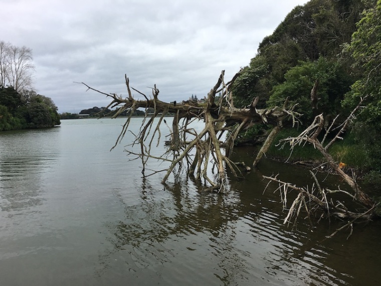
The Orakei Basin Walkway is a 45-minute stroll on foot (not suitable for cycling or wheelchairs) and brings lush scenery and dog-friendly paths. It combines steps, bridges and earthy paths, as you walk along the mouth of what was once (some 85,000 years ago), an active crater lake. Sometimes you can see various groups of people – like these paddle boarders (main photo in this post) out in groups taking in the great day. After the walk, stop for a coffee at Bird On A Wire or any of the lovely coffee stops at the nearby Orakei Village.
A shorter 30-minute alternative is the Panmure Basin walk that takes you along the rim of another extinct crater lake. It is great for kids as it has 3 playground stops along the way, a dedicated and almost flat cycle, tricycle and scooter path and is fairly shaded. A great place to stop for a coffee and sit out on the deck is at the cafe in the Waipuna Conference Centre
A good place with even flatter walkaways perfect for slow walkers, kids cycling or even a wheelchair stroll is the Pakuranga Farmcove Loop that takes you along the Tamaki Estuary, through Farm Cove, and you can have that completed in 30 minutes.
Besides soaking in flora, fauna,sun and scenery, a walk also gives you a chance to ogle at the real estate and the mega homes built around the water. This is a rare backyard peek into what the rest of Asia would consider a good feng-shui purchase – owning a home along the fertile water’s edge. After that head to Howick Village nearby to the Saturday morning market or anywhere in the village for a coffee.
I’ve lived all my life in the eastern side of Singapore. And as we always say, once as East Coaster, always an East Coaster. There’s something about this part of the island that’s different. It’s cosier, more laid back, prettier, and many say, the air is different. I agree on all points. It’s also more residential, tranquil, with little of those multi-lane highways that cut across high rise flats. And for many of us, the beach is within walking distance or at least, a short ride away.
Known for being a seaside resort back in the day, the East Coast has retained its laid back vibe til today. But it’s got its fair share of history, good and bad. During the recent Heritage Fest 2016, the National Heritage Board launched its newest heritage trail that brings you to multiple historically significant spots in the Bedok/Chai Chee area. As it has always been my hunting ground, and being of the vintage that just about remembers its transition from old to modern day, I couldn’t resist tagging along for the preview.
The Bedok Heritage Trail covers 15km and is signposted by 10 markers installed at so-called heritage points on the trail. Little of the old landscape is left today, so you have to do quite a lot of imagining to fill in the gaps. The 60-page trail booklet, which is packed with lots of hard-to-find information, will be essential in having a good heritage experience – and it’s well worth keeping on your bookshelf, too.
We started off at the Bedok Heritage Corner opposite the Bedok Interchange hawker centre where sampan-shaped markers carry information about this area’s history. In a nutshell, the area was full of fishing villages, kampongs, markets, as well as rich men’s beachside manors and military installations. (Being of a certain vintage, I do remember some of the great houses, sand-lined roads, coconut trees and kampongs of yesteryear.)
From there, we trundled along Chai Chee Road which was part of the old road that used to meander through the Bedok Hills to the holiday bungalows of Changi and Loyang. These hills have since been levelled to reclaim the land that makes Marine Parade now. It’s hard to imagine this urban landscape having hills and roads hugging cliff faces, but they were indeed there and still part of my childhood memories.
A section of an old sea wall, and part of Mr Tan Lark Sye’s mansion at the end of Nallur Road.
First stop on the trail was at the end of Nallur Road, where a substantial sea wall still stands. Located opposite the Good Shepherd Kindergarten (my alma mater), the walls and a remaining iron gate are remnants of huge mansions that used to front the seashore. I still remember the house that stood there, owned by the tycoon Tan Lark Sye.
An aerial view of the seafront bungalows along Upper East Coast area in Siglap, 1958. Singapore Land Authority Collection, Courtesy of National Archives of SingaporeThe Good Shepherd Kindergarten at the end of Nallur Road used to be right by the beach.
It was a sprawling manor just opposite my kindergarten, that was fodder for day dreams every time I got bored or when I had finished my colouring assignment early. In the early 70s, Good Shepherd Kindergarten too faced the beach and you could see the waves from the playground. The road in front — now well paved — used to be a sandy track too. These are from my own memories; not mentioned in the trail booklet. Happy days.
From there, we pottered over to Upper East Coast Road, opposite the Hua Yu Wee Seafood Restaurant. Housed in a 1920s bungalow, this restaurant which continues to serve up good seafood even now, is the last of the famous seafood strip which counted the original Long Beach, Red House and Palm Beach Restaurant, all of which I too remember with their welcoming neon signs. Head to the back of the restaurant and peer out at the lush forested patch behind; and keep an eye out for the old hop-scotch grid etched into the painted cement floor which no doubt entertained lots of bored children since decades ago. Even earlier, this area had a restaurant called Wyman’s Haven which the oldies would remember.
An old hopscotch grid at the Hua Yu Wee Restaurant.
These restaurants too used to abut the shoreline, and round Bedok Corner would be hawkers selling seafood by the beach. If you couldn’t afford a restaurant meal, you could still have your seafood fix there. Kampong residents nearby would also head to the beach for parties and regattas during festivals.
Mr Peter Chan, a serious hobby historian with a photo of Wyman Haven. which was owned by his grandmother. The popular restaurant used to stand where Temasek Secondary School currently stands.
Stretching all the way to Fort Road were pillboxes put there by the British army long ago, while fruit and rubber plantations dotted the hills, and kampongs on the lowlands. People here used to be plantation workers, farmers and fishermen. I remember the pillboxes by the beach. Until they were removed in the late 70s and early 80s, we could still walk into those structures and for kids, it was a fantastic place for hide-and-seek. It was only when we got a little older that we became aware of its grim significance.
Indeed, the darker part of Bedok’s history lie in this vicinity. The Japanese massacred thousands of Singaporeans in this area as part of the Sook Ching purge during WWII, and buried them in mass graves. Little is said about them now, but between 1951 and 1966, over 50 mass graves were found in Bedok, Siglap and Tanah Merah containing the bodies of people killed by the Japanese during the war. The largest was near Tanah Merah which contained over 2000 bodies. Jalan Puay Poon, near the junction of Upper East Coast Road and Bedok South Avenue is one of the sites where several mass graves were found. All the bodies have since been interred under the Civilian War Memorial. During the war, the Japanese killed 25,000 to 50,000 people in Singapore, mostly Chinese. This was in retribution for supporting the anti-Japanese movement in China.
Nearer Bedok Corner where the hawker centre sits (known for its famous ching tng stall), is Villa Kahar, an elegant 1920s bungalow which still stands, and once the home of Singapore’s first female doctor, Dr Lee Choo Neo, grand aunt of Mr Lee Kuan Yew. Bedok Corner itself marks a perilous turn for motorcycle and car races (all illegal) that used the long straight stretch of Upper East Coast as a racing track late at night. All this is recorded at yet another marker beside the hawker centre.
This is where we ended the quick preview of Singapore’s latest heritage trail. The only sensible thing to do was to dive into a bowl of ‘ching tng’, all icy and cold and just sweet enough.
The Frankel family with Albert Einstein and other members of the Jewish community, 1922. Image from Bieder, J., & Lau, A. T. (2007) The Jews of Singapore (Singapore: Suntree Media)
The other parts of the trail takes you to Simpang, Fengshan, Tanah Merah, Opera Estate and Frankel Avenue. I grew up in Frankel Estate, and didn’t realise until now that it was named after a Jewish merchant who used to own huge tracts of land there including Opera Estate. I also didn’t know that Albert Einstein had visited Frankel Estate in the 1930s and waxed lyrical about it in his diary, nor did I know that there is a Keramat (shrine) not far away in tribute to an Indonesian prince who was said to have established the old villages in the Bedok area. But I do know that Bedok is one of the earliest recorded areas of Singapore, which had been mentioned in maps as far back as the 16th century.
While you learn lots of things along this trail, there are a few things to note. It is not a walkable trail, so you’ll need a car or at least a bike. The markers give you a short summary of the history of that area, but for the most part, there are no relics to see, except perhaps the sea wall. Rather than walk the trail, I’d say it’s better to just keep a look out for the markers and give it a good look if you are in the vicinity. If you are thinking of making the trail a fun morning out with the family, you will be disappointed.
For one who remembers the old Bedok area, the trail misses lots of the detail, richness and colour. Do the markers do justice to the history of Bedok? I think it falls short. But it is a good effort and does help preserve the heritage of the area. The trail booklet is an impressive work of research and well worth keeping on your bookshelf though. For more details and to download the heritage trail booklet and map, click here.
Good to know: Incidentally the National Heritage Board has recently launched the Singapore Heritage Trails app that contains over 80 heritage trails around Singapore, created by the NHB as well as community groups and schools.